The Endangered Species Act (ESA) of the United States provides for the protection of imperiled species and their habitats. Yet, successful implementation of the ESA is often hindered by a lack of accurate and current data to inform conservation decisions (Bottrill et al. 2008). Camera traps are a powerful tool to collect data that can facilitate implementation of the ESA, such as the occurrence and spatial ecology of terrestrial species (Burton et al. 2015). Camera-traps can be particularly useful to monitor rare or elusive species because cameras are unobtrusive and can monitor continuously for prolonged periods (Sanderson and Trolle 2005; Lukacs et al. 2020). For example, trail cameras have documented the occurrence of jaguar (Panthera onca), margay (Leopardus weidii), and American black bear (Ursus americanus) in Mexico (Ragan et al. 2022; Branney et al. 2023; Marín and Koprowski 2025).
Ocelots (Leopardus pardalis) occur throughout the Americas, reaching the extremes of its range in northeastern Argentina, southern Brazil, southern Arizona and Texas, United States (USA; US Fish and Wildlife Service 2016). Ocelots are federally endangered in the USA (US Fish and Wildlife Service 2016) and Mexico (SEMARNAT 2010). The northernmost known breeding population in Mexico occurs in Rancho El Aribabi, a private conservation ranch in Sonora, Mexico (Rorabaugh et al. 2020). Other northern breeding populations occur in Chihuahua and Tamaulipas, Mexico (Gomez-Ramirez et al. 2015; Lombardi et al. 2022), whereas the only known breeding population in the USA occurs in coastal South Texas (US Fish and Wildlife Service 2016). The ocelot population in coastal South Texas has been monitored for over 40 years (Schmidt et al. 2020; Veals et al. 2023; Smith et al. 2025), and recent research is elucidating ocelot distribution and ecology in northern Mexico (Amador-Alcala et al. 2022; Sternberg et al. 2023; VanDevender et al. 2023). However, little information exists about the occurrence and distribution of ocelots in Arizona.
Historical evidence of ocelots in Arizona is sparse with one fossil record and 11 historical records (e.g., carcass, skull, pelt, etc.) between 1887 and 1980. One historical record was confirmed as female, and the rest were male or of unknown sex (US Fish and Wildlife Service 2016). No ocelots were officially confirmed in Arizona between 1980 and 2009 with illegal hunting and habitat loss driving declines throughout their range (US Fish and Wildlife Service 2016). However, due in part to increased use of camera-traps, at least six unique ocelots have been detected in Arizona since 2009 (Culver 2016; Gamillo 2024). All detections since 2009 have been males, presumably dispersing from breeding populations in Sonora, Mexico, the closest of which is roughly 55 km south of the international border (Rorabaugh et al. 2020). However, no genetic or telemetry studies have shown definitively the origin of these Arizona detections (US Fish and Wildlife Service 2016).
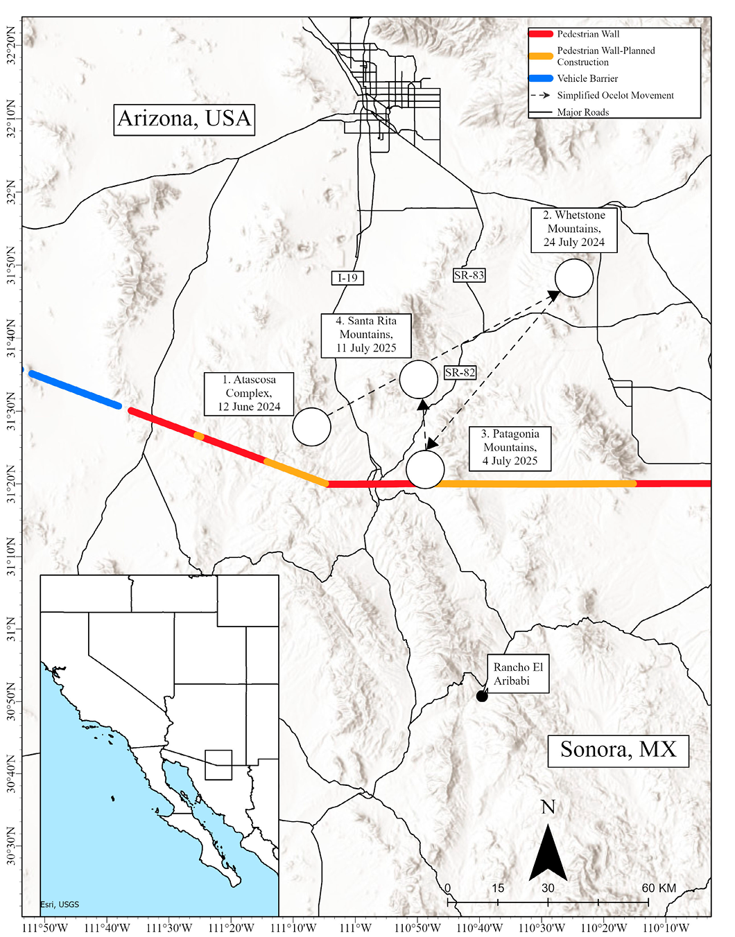
Given the scarcity of ocelot detections, any new information on the occurrence and spatial ecology of ocelots in Arizona is valuable for state and federal natural resources agencies tasked with protecting this endangered species. Such data will be particularly useful as climate change drives species distributions northward (Chen et al. 2011), habitat loss affects the northernmost breeding population of ocelots in Sonora (Rorabaugh et al. 2020; Ávalos 2023), and border wall construction expands across the USA-Mexico border (Harrity et al. 2024). New data are especially important considering that no critical habitat for ocelots has been designated in Arizona despite the species being listed as endangered at the state and federal level for decades (US Fish and Wildlife Service 2016). Here, we report novel observations of the seventh confirmed ocelot in Arizona since 2009 to further conservation efforts.
We maintained non-baited camera-traps at 89 locations in the Madrean Sky Islands of southern Arizona between April 2024 and October 2025 (Figure 1). The Madrean Sky Islands are a global biodiversity hotspot spanning the USA-Mexico border at the convergence of major biogeographical regions, including Sonoran Desert, Chihuahuan Desert, Rocky Mountains, and Sierra Madre Mountains (VanDevender et al. 2013). Camera model, settings, and spatial arrangement varied by organization. Phoenix Zoo maintained 50 Bushnell No-Glow cameras (Bushnell Holdings, LLC., Overland Park, Kansas) at randomized locations in the Atascosa Complex with a minimum distance between camera sites of two km. Cameras were set to capture 10-second videos with a 1-min delay. Sky Island Alliance maintained eight Reconyx UltraFire (Reconyx, Inc., Holmen, Wisconsin) and six Browning Strikeforce (Browning Trail Cameras, Birmingham, Alabama) cameras in the Patagonia Mountains arranged in two systematic grids with 0.5 - 1.0 km spacing between cameras (Jansen et al. 2014). All cameras maintained by Sky Island Alliance were programmed to capture 1 - 3 photos with a 1-min delay. University of Arizona Wild Cat Research and Conservation Center maintained 24 cameras in the Santa Rita and Whetstone Mountains as part of a regional spotted cat monitoring effort (Culver 2016). Cameras were placed in drainages or at water sources and set to collect 1 - 3 photos with a 1-min delay following methods described in Culver (2016). A private individual maintained an additional GardePro camera (GardePro, Hong Kong) in the Whetstone Mountains. All cameras, regardless of organization, were programmed to operate continuously, mounted 0.2 - 1.5 m above the ground on sturdy vegetation, and oriented to optimize terrestrial wildlife detection. We reviewed photos and videos to identify species detected and count individuals present. We identified the ocelot individual by matching at least three unique patterns of spots in each detection (Trolle and Kéry 2003). We calculated displacement distances (km) as straight-line distances between detection locations and calculated average daily displacement distances as the straight-line distance between sequential detections divided by days elapsed between the detections. We also characterized vegetation communities for all camera sites following Brown and Lowe (1980). Cameras on public land were permitted under US Forest Service Special Use Permits SUP2349, NOG2405, and SUP2388.
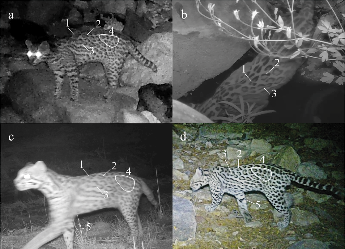
We detected a male ocelot four times in four different mountain ranges over 388 days (Figure 1; Table 1). We confirmed the ocelot was the same individual by matching up to five unique spot patterns on the back, flank, and inner leg (Figure 2) and determined sex by the presence of a scrotum. The minimum displacement distance was ≥ 178.4 km with step-lengths between subsequent detections of 78.9 km, 68.0 km, and 31.5 respectively (Table 1). The minimum convex polygon of the detection locations was 1,085 km2. Only seven days elapsed between the third and fourth detection, giving an average daily displacement distance of 4.5 km. All detections occurred at night during summer months (June and July) and occurred in drainages. Dominant vegetation community of each detection location included, Encinal Oak, Chihuahuan Desert Scrub, and Desert Scrub Grassland, and elevation ranged from 1,152 - 1,569 m (Table 1).
These four detections contribute to our understanding of ocelot occurrence in Arizona and the spatial ecology of the species. Indeed, these observations represent the longest-known displacement by an ocelot anywhere within its range (US Fish and Wildlife Service 2016). Notably, this was the first confirmed ocelot in the Atascosa Complex, the second confirmed ocelot in the Whetstone Mountains (first since 2009; Avila-Villegas and Lamberton-Moreno 2013) and Santa Rita Mountains (first since 2015; Culver 2016), and the seventh ocelot in Arizona since 2009. Finally, these detections in four mountain ranges by four camera networks underscore the importance of maintaining connectivity throughout the region as well as the need for collaboration and data sharing to achieve conservation goals.
Our observations demonstrate the remarkable movement capacity of this species. For example, the ocelot covered ≥ 31.5 km between the Patagonia Mountains (detection three) and the Santa Rita Mountains (detection four) in seven days. This gives an average daily displacement of 4.5 km, greater than distances observed in telemetry studies (2.5 km; Gonzalez-Borrajo et al. 2017) and camera-trapping studies (e.g., 2.3 - 2.4 km; Lombardi et al. 2022). The minimum displacement distance of this ocelot was 178.4 km — more than two times greater than the next longest reported displacement (an 84-km round-trip movement in Arizona; Culver 2016). As no known breeding populations exist in Arizona, this ocelot presumably dispersed from the northernmost breeding population in Rancho El Aribabi, Sonora, which lies roughly 80 km south of our first detection (Rorabaugh, et al. 2020). Ocelots exhibit sex-based dispersal with males moving greater distances than females (Gonzalez-Borrajo et al. 2017), and this behavior probably explains why all ocelots confirmed in Arizona since 2009 (including our recent detections) have been male.
We detected the ocelot in Encinal Oak, desert grassland, and desert scrub vegetation communities, which is consistent with ocelot habitat preferences in Sonora (VanDevender et al. 2023). Moreover, the detections occurred in drainages, emphasizing the importance of riparian corridors for wildlife connectivity and access to water in arid regions (Ragan et al. 2023). Recent research from Sonora also documented ocelot use of riparian corridors (Rorabaugh et al. 2020). Importantly, whereas the detection locations conformed with known ocelot habitat preferences, much of the landscape between the detection locations is predicted as low suitability for ocelots (NatureServe and Heritage Network Partners 2021). This highlights the need to protect suitable habitat and the movement corridors between habitat patches to successfully conserve mobile species.
Conservation of wide-ranging species is challenging because their movements may bring them into regular contact with human development and other stressors (Nandintsetseg et al. 2019). Indeed, vehicle collisions are a leading cause of mortality of ocelots in Texas (Schmidt et al. 2020; Veals et al. 2023). The ocelot we observed must have crossed busy roadways multiple times when moving between the mountain ranges, including Interstate-19 (I-19), a multi-lane highway with abundant commercial traffic between Sonora and Arizona (Figure 1). Annual average daily traffic volumes in 2024 were 39,072.5 ± 24,806.2 vehicles/day (ADOT 2025), well above the threshold for avoidance by ocelots (5,000 vehicles/day) observed in Texas (Veals et al. 2023). In addition to I-19, this ocelot likely crossed State Routes 82 or 83 at least three times when moving between mountain ranges (Figure 1). Traffic volumes on these state routes are lower than I-19 (2,333.9 ± 1,229.6 vs 39,072.5 ± 24,806.2 vehicles/day) and they are typically only two lanes, but maximum speed limits are high (90 km/h). The potential crossings by this ocelot emphasize the need for wildlife crossing structures to facilitate safe wildlife movement across transportation infrastructure.
Limitations of camera-traps are highlighted by our observations as we cannot know how this ocelot moved between camera locations, nor whence it came. The origin of this ocelot is particularly relevant because a railroad was constructed through Rancho El Aribabi in 2023 to connect with railroads near Nogales, Arizona (Ávalos ٢٠٢٣). The habitat loss and fragmentation from this development could negatively impact local ocelot populations (Kotze et al. 2021; Kuipers et al. 2021) and may lead to increased ocelot dispersal away from the area (i.e., frustrated dispersal). Loss of ocelot habitat in Rancho El Aribabi, coupled with our detections in Arizona, reinforce the need for telemetry and genetic studies to elucidate movement corridors and connectivity between countries.
Beyond these threats, ocelots face multiple conservation challenges in the region. For example, ≥ 1000 km of border walls measuring 5.5 - 9.1 m tall and with interstitial spaces averaging ≤ 10 cm exist along the USA-Mexico border. Importantly, at least 450 km of new border wall projects were initiated in 2025 (US Customs and Border Protection 2025) that will dramatically reduce wildlife connectivity along the entire USA-Mexico border (Flesch et al. 2010; Peters et al. 2018; Harrity et al. 2024). Existing wildlife crossing structures improve crossing rates for some species but should be made larger and installed more frequently in existing and future walls to provide for some cross-border connectivity (Harrity et al. 2024). Mining operations are also expanding that will degrade or destroy potentially suitable ocelot habitat (e.g., Hermosa Mine in Arizona, Buenavista Copper Mine in Sonora, etc.). Additionally, southern Arizona has several inventoried roadless areas that support potentially suitable habitat for ocelot and many other imperiled species (NatureServe and Heritage Network Partners 2021). Recent efforts to rescind the Roadless Area Conservation Rule in the USA (US Department of Agriculture 2025) may have strong negative impacts to habitat quality of these areas by increasing anthropogenic disturbance and activity (Selva et al. 2015). Finally, climate change may drive ocelot distribution northward (Chen et al. 2011) and into an increasingly fragmented and densely populated landscape in southern Arizona (US Census Bureau 2024). Rather than reacting to these conservation challenges if ocelots recolonize Arizona, the opportunity exists to proactively ensure suitable habitat and adequate connectivity exist within the region and across the USA-Mexico border. Additionally, the mounting evidence of ocelot occurrence and movement throughout the Madrean Sky Islands of southeastern Arizona could justify the designation of critical ocelot habitat in the region. Such actions would facilitate conservation of ocelots under the US ESA and would be an important step towards the successful recovery of this endangered species.
Acknowledgements
Funding was provided by the Wilburforce Foundation, the Phoenix Zoo, the Arthur L. and Elaine V. Johnson Foundation, and many individual donors. Private land access was provided by anonymous landowners in Santa Cruz County, Arizona. S. Malusa and the University of Arizona Wild Cat Research and Conservation Center have advanced spotted cat conservation in Arizona and shared details of the ocelot observation from the Santa Rita Mountains. R. McSpadden shared the ocelot observation from the Whetstone Mountains. For Sky Island Alliance: M. Bethel, O. Anderson, M. Tighe, M. Stock, and B. Thornton assisted with data processing, and R. Quade and M. Hudson assisted with camera maintenance. For the Phoenix Zoo: S. Mulder, T. Egan, and L. Bly assisted with data processing and A. Lotfi and J. Schipper assisted with camera maintenance. Lastly, thanks to E. Burns and R. Allard and two anonymous reviewers for editorial guidance to improve this manuscript.
Literature Cited
Arizona Department of Transportation Highway Performance Monitoring System (ADOT). 2025. https://azdot.gov/sites/default/files/2025-06/2024-AADT-PUBLICATION_Interstate.pdf. Accessed on 17 October 2025.
Amador-Alcala, S. A., et al. 2022. Abundance and home range of ocelot (Leopardus pardalis) in northwestern Mexico. Animal Biology 84:1–17.
Ávalos, J. M. 2023. En secreto, arranca tala de árboles de área natural protegida en Sonora para nuevas vías de tren. Animal Politico. https://animalpolitico.com/estados/rancho-el-aribabi-imuris-sonora-vias-tren. Accessed on 17 October 2025.
Avila-Villegas, S. and J. Lamberton-Moreno. 2013. Wildlife survey and monitoring in the Sky Island region with an emphasis on neotropical felids. Pp. 441–447 In Merging science and management in a rapidly changing world: Biodiversity and management of the Madrean Archipelago III and 7th Conference on Research and Resource Management in the Southwestern Deserts. (Gottfried, G. J., Ffolliott, P. F., Gebow, B. S.; Eskew, L. G., Collins, L. C., eds). 2012 May 1–5; Tucson, AZ. RMRS-P-67. Fort Collins, Colorado. US Department of Agriculture, Forest Service, Rocky Mountain Research Station.
Bottrill, M. C., et al. 2008. Is conservation triage just smart decision making? Trends in Ecology and Evolution 23:649–654.
Branney, A. B., et al. 2023. Jaguars, ocelots, coatimundis… oh my: Species composition and temporal overlap of a diverse carnivore guild in the Sierra of Tamaulipas, México. Global Ecology and Conservation 44:e02493.
Brown, D. E. and C. H. Jr. Lowe. 1980. Biotic communities of the Southwest. USDA Forest Service and University of Utah, Salt Lake City, Utah.
Burton, A. C., et al. 2015. Wildlife camera trapping: A review and recommendations for linking surveys to ecological processes. Journal of Applied Ecology 52:675–685.
Chen, I. C., et al. 2011. Rapid range shifts of species associated with high levels of climate warming. Science 333:1024–1026.
Culver, M. 2016. Jaguar surveying and monitoring in the United States (Open-File Report). No. 2016-1095. US Geological Survey.
Flesch, A. D., et al. 2010. Potential effects of the United States-Mexico border fence on wildlife: Contributed paper. Conservation Biology 24:171–181.
Gamillo, E. 2024. Rare ocelot caught on camera in Arizona, the first sighting in its area for 50 years. Smithsonian Magazine. https://www.smithsonianmag.com/smart-news/rare-ocelot-caught-on-camera-in-arizona-the-first-sighting-in-its-area-for-50-years-180984921/ Accessed on 16 January 2026.
Gómez-Ramírez, M. Á., C. E. Gutiérrez-González, and C. A. López-González. 2017. Ocelots thrive in a non-typical habitat of northwestern Mexico. Endangered Species Research 32:471–478.
Gonzalez-Borrajo, N., J. V. López-Bao, and F. Palomares. 2017. Spatial ecology of jaguars, pumas, and ocelots: a review of the state of knowledge. Mammal Review 47:62–75.
Harrity, E. J., et al. 2024. USA-Mexico border wall impedes wildlife movement. Frontiers in Ecology and Evolution 12:1487911.
Jansen, P. A., et al. 2014. TEAM: a standardised camera trap survey to monitor terrestrial vertebrate communities in tropical forests. Pp. 263–270 In Camera trapping: Wildlife management and research. P. Meek, P. Fleming, G. Ballard, P. Banks, A. Claridge, J. Sanderson, and D. Swann, eds.) CSIRO Publishing, Collingwood, Victoria, Australia
Kotze, R., et al. 2021. Demographic consequences of habitat loss and crowding in large carnivores: A natural experiment. African Journal of Ecology 59:63–73.
Kuipers, K. J. J., et al. 2021. Habitat fragmentation amplifies threats from habitat loss to mammal diversity across the world’s terrestrial ecoregions. One Earth 4:1505–1513.
Lombardi, J. V., et al. 2022. Ocelot density and habitat use in Tamaulipan thornshrub and tropical deciduous forests in Northeastern México. Journal of mammalogy 103:57–67.
Lukacs, P. M., et al. 2020. Wolverine occupancy, spatial distribution, and monitoring design. Journal of Wildlife Management 84:841–851.
Marín, G., and J. L. Koprowski. 2025. Mammals on the edge: how the border wall, roads, and riparian areas impact mammal populations along the US-Mexico boundary. Science of the Total Environment 988:179833.
Nandintsetseg, D., et al. 2019. Challenges in the conservation of wide-ranging nomadic species. Journal of Applied Ecology 56:1916–1926.
NatureServe and Heritage Network Partners. 2021. Species distribution model for Ocelot (Leopardus pardalis). Created on August 30, 2021. Arlington, Virginia.
Peters, R., et al. 2018. Nature divided, scientists united: US–Mexico border wall threatens biodiversity and binational conservation. BioScience, 68:740–743.
Ragan, K., et al. 2022. Co-occurrence of four endangered mammals in the Mexico–United States borderlands: jaguar (Panthera onca), ocelot (Leopardus pardalis), beaver (Castor canadensis) and black bear (Ursus americanus). The Southwestern Naturalist 66:77–83.
Ragan, K., et al. 2023. Mammal use of riparian corridors in semi-arid Sonora, Mexico. Journal of Wildlife Management 87:e22322.
Rorabaugh, J. C., et al. 2020. Ecology of an ocelot population at the northern edge of the species’ distribution in northern Sonora, Mexico. PeerJ 8:e8414.
Sanderson, J. G. and M. Trolle. 2005. Monitoring elusive mammals: unattended cameras reveal secrets of some of the world’s wildest places. American Scientist 93:148–155.
Schmidt, G. M., R.L. Lewison, and H. M. Swarts. 2020. Identifying landscape predictors of ocelot road mortality. Landscape Ecology 35:1651–1666.
Selva, N., et al. 2015. Why Keep Areas Road-Free? The Importance of Roadless Areas. Pp. 16–26 in Handbook of Road Ecology (R. van der Ree, D. J. Smith, and C. Grilo, eds). John Wiley & Sons, Ltd. West Sussex, UK.
Secretaría de Medio Ambiente y Recursos Naturales (SEMARNAT). 2010. Norma Oficial Mexicana NOM-059-SEMARNAT-2010, Protección ambiental-Especies nativas de México de flora y fauna silvestres - Categorías de riesgo especificaciones para su inclusión, exclusión o cambio- lista de especies en riesgo. Secretaría del Medio Ambiente y Recursos Naturales.México.30 December 2010. México City, México.
Smith, M. M., et al. 2025. Sex-specific resource strategies mediate home range sizes of an endangered carnivore across multiple scales. Scientific Reports 15:34190.
Sternberg, M. A., et al. 2023. Characteristics of ocelot populations in Tamaulipas, Mexico, using capture recapture techniques. Endangered species research 52:113–127.
Trolle, M., and M. Kéry. 2003. Estimation of ocelot density in the Pantanal using capture-recapture analysis of camera-trapping data. Journal of Mammalogy 84:607-614.
US Census Bureau. 2024. https://www.census.gov/data/tables/time-series/demo/popest/2020s-state-total.html. Accessed on October 17, 2025.
US Customs and Border Protection. 2025. https://www.cbp.gov/newsroom/national-media-release/dhs-cbp-award-45b-new-contracts-under-obbb-smart-wall-construction. Accessed on 17 October 2025.
US Department of Agriculture. 2025. https://www.usda.gov/about-usda/news/press-releases/2025/06/23/secretary-rollins-rescinds-roadless-rule-eliminating-impediment-responsible-forest-management. Accessed on 17 October 2025.
US Fish and Wildlife Service. 2016. Recovery plan for the Ocelot (Leopardus pardalis), first revision. US Fish and Wildlife Service Southwest Region Albuquerque: Albuquerque, New Mexico, USA, 217.
VanDevender, T. R., et al. 2013. Biodiversity in the Madrean Archipelago of Sonora, Mexico. Pp. 10–16. In Merging science and management in a rapidly changing world: Biodiversity and management of the Madrean Archipelago III and 7th Conference on Research and Resource Management in the Southwestern Deserts. (Gottfried, G. J., Ffolliott, P. F., Gebow, B. S.; Eskew, L. G., Collins, L. C., eds). 2012 May 1–5; Tucson, AZ. In Archipelago III. Proceedings. RMRS-P-67. Fort Collins, Colorado. US Department of Agriculture, Forest Service, Rocky Mountain Research Station.
VanDevender, T. R., et al. 2023. Distribution and habitat of Ocelot (Leopardus pardalis) in Sonora, México. Therya 14:245–252.
Veals, A. M., et al. 2023. Landscape connectivity for an endangered carnivore: habitat conservation and road mitigation for ocelots in the US. Landscape Ecology 38:363–381.
Associated Editor David Valenzuela Galván
Submitted: october 31, 2025;Reviewed: november 18, 2025; Accepted: january 29, 2026; Published online: March 27, 2026