THERYA NOTES 2024, Vol. 5 : 261-267 DOI: 10.12933/therya_notes-24-183 ISSN 2954-3614
Traces of coyote Canis latrans in the subalpine altitudinal gradient of Parque Nacional Chirripó, Costa Rica, and altitudinal review of the distribution area
Rastros de coyote Canis latrans en el gradiente altitudinal subalpino del Parque Nacional Chirripó, Costa Rica, y revisión altitudinal del área de distribución
Yara Azofeifa-Romero1*, Marco Gabriel Gutiérrez-Gómez2, 3, and Francisco Javier Durán-Alvarado4
1Laboratorio de Sistemática, Genética y Evolución (LabSGE), Escuela de Ciencias Biológicas, Universidad Nacional. Avenida 1, Calle 9, Campus Omar Dengo, C. P. 86-3000. Heredia, Costa Rica. E-mail: yara.azofeifa.romero@una.ac.cr (YA-R).
2Escuela de Ciencias Geográficas, Universidad Nacional. Avenida 1, Calle 9, Campus Omar Dengo, C. P. 86-3000. Heredia, Costa Rica. E-mail: gomgagu@gmail.com (MGG-G).
3Maestría en Desarrollo Rural (PGDR), Universidade Federal do Rio Grande do Sul (UFRGS). Av. Paulo Gama, 110, Bairro Farroupilha, Porto Alegre, C. P. 90040-060. Rio Grande do Sul, Brasil.
4Museo Nacional de Costa Rica. Cuesta de Moras, Av. Central y Segunda, San José, Bella Vista, C. P. 749-1000, San José. Heredia, Costa Rica. E-mail: fduran@museocostarica.go.cr (FJD-A).
*Corresponding author
The coyote is one of the American canids with the broadest geographic distribution. Although it is a common species, the upper limit of its altitudinal distribution has yet to be established. This study aims to contribute to the recording of coyote traces in a subalpine forest in the Cordillera de Talamanca, Costa Rica, and reviews its altitudinal distribution in México and Central America. We traveled 4.36 km between elevations of 3,118 to 3,821 m (the maximum altitude), to georeference and photograph coyote traces in the Parque Nacional Chirripó, Costa Rica. We asked locals and park rangers about coyote traces or sightings. In addition, we reviewed coyote reports in 2 research projects in Costa Rica and biodiversity platforms that covered México and Central America to contextualize the results. Indirect evidence was gathered of the presence of coyote in most of the walk up to the top of Cerro Chirripó. The evidence recorded at 3,821 m corresponds to a scat with length and diameter characteristic of this canid. In addition, we noted that the reports of coyotes in subalpine areas available on biodiversity platforms are scarce. The record in this study is consistent with the high dispersal capacity of this species and raises some questions about the use of resources, behavior, and altitudinal range of the coyote in Central America.
Key words: Altitudinal range; Central America; coyote; feces; México; subalpine forest; Talamanca mountain range.
El coyote es uno de los cánidos americanos con mayor distribución geográfica. A pesar de ser una especie común, su máxima distribución altitudinal no ha sido claramente establecida. Nos propusimos contribuir con el registro de rastros de coyote en un bosque subalpino de la Cordillera de Talamanca, Costa Rica, y con la revisión de su distribución altitudinal en México y Centro América. Recorrimos 4.36 km entre 3,118 - 3,821 m hasta alcanzar la máxima altitud, para georreferenciar y fotografiar rastros de coyote en el Parque Nacional Chirripó en Costa Rica. Consultamos a personas locales y guardaparques acerca de rastros o avistamientos de coyote. Además, revisamos los reportes de coyote en 2 proyectos de investigación en Costa Rica y en las plataformas de biodiversidad, abarcando México y Centroamérica, para contextualizar los resultados. Obtuvimos evidencia indirecta de presencia de coyote en la mayor parte del recorrido hasta alcanzar la máxima altitud del Cerro Chirripó. La evidencia registrada a 3,821 m corresponde a una excreta que posee la longitud y el diámetro característicos para este cánido. Además, observamos que los reportes de coyote en las plataformas de biodiversidad siguen siendo deficientes en el piso subalpino. Este registro concuerda con la alta capacidad de dispersión de esta especie y, además, plantea algunas interrogantes sobre el uso de recursos, comportamiento, y distribución altitudinal del coyote en Centro América.
Palabras clave: Bosque subalpino; Centro América; Cordillera de Talamanca; coyote; distribución altitudinal; heces; México.
© 2024 Asociación Mexicana de Mastozoología, www.mastozoologiamexicana.org
The coyote Canis latrans (Say 1823) is one of the canids with the broadest distribution in the American continent. This remarkably adaptable mammal has been recorded from Alaska to Darién, Panamá, with fossil records from the Holocene, precolonial archaeological evidence, and documents from the colonial period throughout its range (Bekoff 1977; Monge-Nájera and Morera-Brenes 1986; Lucas et al. 1997; Emery 1999; Hidalgo-Mihart et al. 2004; Ordóñez-Garza et al. 2008; Hody and Kays 2018; Hody et al. 2019; Thiel 2020). As an omnivorous and opportunistic species, C. latrans moves between natural and anthropic environments, including crops, rural roads, and, to a lesser extent, urban areas, in search of prey or to establish territories (Hancock and Hedrick 2018; Zepeda et al. 2021; Reid and Gómez-Zamora 2022). These environments are part of its home range, with an area between 1.7 km2 and 60 km² (Grinder and Krausman 2001; Zepeda et al. 2021; Lloyd et al. 2022). Given its highly adaptable behavior and ability to move, the coyote will probably be recorded further south of Darién in the near future (Vaughan 1983; Monroy-Vilchis et al. 2020).
In Costa Rica, the coyote is widely distributed from the northwest to the southern Pacific, as well as in the Guanacaste, Tilarán, Central Volcanic, and Talamanca mountain ranges, in addition to the North Caribbean (Cove et al. 2012; Carazo-Salazar et al. 2020; Reid and Gómez-Zamora 2022). The coyote shows a continuous altitudinal distribution in Costa Rica, from basal region to the subalpine areas, with altitudes of up to 3,400 m in Cerro de la Muerte, south of the central belt of the Talamanca mountain range (Vaughan 1983; Wainwright 2007). This canid has also been spotted at altitudes above 3,000 m in the Sierra del Ajusco, south of México City; Pico de Orizaba, east of México City; Santa Catarina Ixtepeji, southern México; Sierra de los Cuchumatanes, western Guatemala; and Cabricán, in the western plateau of southwest Guatemala (Handley 1950; Aranda et al. 1995; Ordóñez-Garza et al. 2008; Cruz-Espinoza et al. 2010; Martínez-Vázquez et al. 2010; Marín-Sánchez et al. 2015). At these altitudes, subalpine environments pose a challenge to the tolerance of wildlife (Martin 2001). However, in this fragile life zone, coyotes coexist with a rich assemblage of herbivorous, omnivorous, and carnivorous mammals (González et al. 2021).
As with other mammals, reports of coyote sightings in subalpine regions are scarce, and its presence is usually detected mainly by footprints, feces, vocalizations, and, to a lesser extent, through camera traps. In the case of Costa Rica, the altitudinal limits along the highest mountain ranges, i.e., the Central Volcanic and Talamanca mountain ranges, have yet to be established. For the latter mountain range, this study aimed to contribute to the recording of coyote traces (feces, footprints, sightings, and vocalizations) in the subalpine area of Parque Nacional Chirripó (PNC). In addition, to contextualize the data collected in the field and contribute to the knowledge of the ecology of this species in Costa Rica, particularly concerning its altitudinal distribution, we reviewed the records of the research projects “Ethnoecology of C. latrans” of the Universidad Nacional (UNA) and “Moorlands” of the Museo Nacional de Costa Rica (MNC), as well as the records available on the online biodiversity platforms that cover México and Central America.
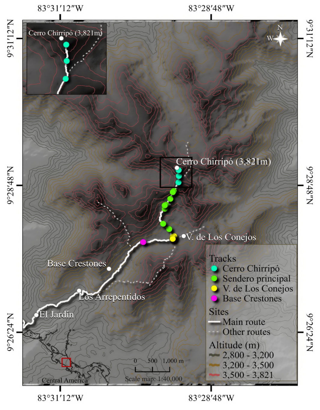
The PNC stretches over 50 thousand ha, ranging from premontane to subalpine altitudes, and is located between the cantons of Pérez Zeledón, Turrialba, Limón, and Talamanca (Tosi 1969; Sistema Nacional de Áreas de Conservación, SINAC, n.d.). The mean annual temperature in the PNC is 8 °C, and the mean annual precipitation varies between 2,000 mm and 5,500 mm (IMN 2008). The subalpine area of the PNC is located at 9° 26' 53''–9° 32' 51'' N and 83° 27' 78''–83° 32' 94'' W (Figure 1). This area is characterized by stunted vegetation, abundant grasses, slopes made up of rounded rocks, and valleys and lagoons of glacial origin (Barquero and Ellenberg 1985). Regarding the composition of mammals in the PNC, the species recorded in addition to the coyote include jaguar (Panthera onca), puma (Puma concolor), clouded oncilla (Leopardus pardinoides), Baird’s tapir (Tapirus bairdii), red brocket (Mazama temama), collared peccary (Dicotyles tajacu), Dice’s cottontail rabbit (Sylvilagus dicei), shrew (Cryptotis sp.), and several species of rodents, e.g., Scotinomys xerampelinus and species of Reithrodontomys, such as R. creper and R. sumichrasti (Chaverri 2008; González-Maya and Schipper 2008; González et al. 2021; Mora et al. 2021). The nearest town is San Gerardo de Rivas, located approximately 14 km from the study area. The presence of feral dogs has not been recorded in the PNC by park rangers, nor has control of domestic dogs been required, as in other protected areas or private reserves.
As part of UNA’s project “Ethnoecology of C. latrans”, which covered the basal, premontane, montane, and subalpine regions of Costa Rica, we carried out a tour from 23 to 25 September 2021 in the subalpine belt of the PNC. Previously, we reviewed MNCR's “Moorlands” project records obtained in the PNC during 2018 to confirm coyote observation sites. Furthermore, during the field trip, we asked a local inhabitant, 2 muleteers, and a park ranger about coyote traces. In the subalpine belt, 2 observers worked in an area of approximately 17.4 km2, walking trails and open zones of the moorland ecosystem, mainly during the mornings, to avoid afternoon winds, fog, and freezing precipitation. We covered 4.36 km in 3 days, organizing the walks during the hours of best visibility to maximize the detection of traces. The altitudinal range walked was 3,118 m to 3,821 m to the top of Cerro Chirripó. On day 1, the search for traces started on the El Jardín trail and continued along the Los Arrepentidos trail. On day 2, we explored the surroundings of the Base Crestones lodge and Valle de Los Conejos. Finally, on day 3, we walked the trail that leads to Cerro Chirripó. All the studied sites have a typical moorland ecosystem. Some trails are harder to climb, while others, such as the surroundings of the Base Crestones lodge, have flat areas with slopes. On the other hand, the Valle de Los Conejos is flat and open, as its name suggests.
During the tours, we georeferenced and photographed each trace, placing a 50-colon coin on one side to facilitate estimating the dimensions of the trace, considering the diameter of the coin (27.5 mm) and using the package tpsDIG2 version 2.32 (Rohlf 2018). Finally, we compared the measurements recorded in this study with those reported by Chame (2003) and Aranda (2012) to confirm field identification. In the case of scats, we applied 2 criteria to differentiate the coyote from other wild and domestic species. The first assumes that coyote scats could be misidentified as those of other wild species such as the gray fox (Urocyon cinereoargenteus) and the puma (P. concolor). However, gray fox scats are rare and smaller, whereas puma feces tend to have many more constrictions than those of coyotes, so they are commonly misidentified as jaguar feces rather than coyote scats (Aranda 2012). The second criterion relates to differences in diet between wild and domestic species. Generally, coyote scats contain many hairs and some skeletal remains of small mammals, while the feces of domestic dogs are homogeneous, with no visible undigested fragments. Therefore, examining feces in the field allowed us to rule out domestic dogs. Photographs of coyote scats and one video were deposited on the ResearchGate site of the first author.
The coyote traces found were projected onto a topographic map of the study area elaborated in QGIS version 3.16.15. T (QGIS.org 2022). Additionally, we made descriptive comparisons of the number of reports using Holdridge's altitudinal levels (Holdridge 1978), namely basal (0–700 m), premontane (700–1,400 m), montane (1400–2,800 m), subalpine (2,800–3,880 m), and alpine (>3,880 m) in México and Central America. To this end, we used reports for C. latrans, such as sightings, traces, or collection specimens reported at the Global Biodiversity Information Facility (GBIF 2024) and iNaturalist (2024), in addition to the records of UNA and MNCR research projects for several regions of Costa Rica. Data from biodiversity platforms were downloaded with the R packages rgbif version 3.7.9 (Chamberlain et al. 2024) and rinat version 0.1.9 (Barve and Hart 2022). We refined the database generated using the R packages dplyr version 1.3.1 (Wickham et al. 2023) and elevatr version 0.99.0 (Hollister 2023). This refinement consisted of eliminating invalid geographic coordinates and assigning altitudes when they were absent. Finally, we used the R package ggplot2 version 3.4.4 (Wickham 2016) to design elevation frequency plots for México and Central America.
Twenty-two coyote scats were recorded during the 4.36 km walk (Table 1; Figure 1). No footprints or sightings were observed between El Jardín and the top of Cerro Chirripó; however, vocalizations were heard on the second day. We measured 9 scats (Figure 2); the rest of the recorded feces were not measured due to their state of decomposition and high moisture content, which can increase their volume and, therefore, bias their true dimensions (Table 1). However, the location of these traces on the trails is consistent with the defecation behavior of this canid; in addition, the scat morphology and contents (items consumed), identified in situ, were consistent with the descriptions reported. Traces were detected from the Base Crestones lodge, in Valle de Los Conejos, and on the trail leading to the top of Cerro Chirripó (Figure 1). However, the sources consulted reported previous sightings in the first 2 sectors, i.e., El Jardín and Los Arrepentidos.
We confirmed the existence of coyote latrines in Valle de Los Conejos based on the information provided by a park ranger and documented in MNCR's Moorlands project. This site, located at approximately 3,470 m, was the only one where we observed groups of scats separated from each other by approximately 2 m (Table 1). The highest frequency of scats was observed between the Base Crestones lodge and Valle de Los Conejos, on trails located between 3,400 m and 3,550 m and between 3,600 m and 3,700 m, with a total of 10 and 8 scats in each altitudinal range, respectively. Above 3,700 m, only 4 coyote scats were observed, 3 of them at the highest altitude recorded in Costa Rica, 3,821 m, at the top of Cerro Chirripó (Table 1).
Regarding our survey about the reported C. latrans traces in México and Central America, we found a total of 9,499 records of C. latrans with valid geographic coordinates after downloading and cleaning data from GBIF and iNaturalist on August 26, 2024. Of these, 9,036 records (95 %) correspond to México since June 20, 1818, including fossils, preserved specimens, sightings, and traces. Costa Rica ranks second, with 296 reports (3 %) since July 11, 1967, including sightings, traces, and a single preserved specimen. The countries with scarce data are Panamá (n = 57) since May 4, 2019; Honduras (n = 41) since March 25, 1946; Guatemala (n = 37) since May 17, 1986; El Salvador (n = 17) since December 29, 1926; Belize (n = 10) since September 15, 2015; and Nicaragua (n = 5) since January 10, 1996 (Figure 3a-c). It should be noted that Guatemala, Honduras, and Nicaragua have records of sightings and preserved specimens; Belize and Panamá only have records of sightings; and for El Salvador the type of material is not indicated. For its part, data from the “Moorlands” (2004-2019) and “Ethnoecology of C. latrans” (2019-2023) research projects totaled 1,047 and 184 coyote records, respectively, from various altitudinal regions of Costa Rica, including sightings, footprints, scats, and vocalizations.
When considering the altitudinal levels of Holdridge (1978), it was observed that the reports collected from the platforms surveyed mainly correspond to the layer between the basal (0 m to 700 m) and montane (1,400 m to 2,800 m) levels. In the most mountainous countries, such as México, Guatemala, and Costa Rica, the reports cover all altitudinal levels, including subalpine (2,800 m to 3,879 m) and alpine (from 3,885 m to 4,578 m) areas, with records for the latter only in México (Figure 3a-c). In México, 32 % of the reports correspond to the basal layer, 17 % to the premontane, 46 % to the montane, and 4 % to the subalpine layers. At higher altitudes, above 4,000 m, reports are concentrated in areas near the Pico de Orizaba (4,578 m), the Popocatépetl Volcano (4,210 m), and the Nevado de Toluca (4,110 m; Figure 3a). For their part, Guatemala and Costa Rica have reports from the basal to the subalpine layers, while Honduras and Nicaragua have only for the montane layer. Guatemala has 36 % of the records on the basal floor, 25 % on the premontane, 21 % on the montane, and 18 % on the subalpine layers. Costa Rica has 31 % on the basal floor, 19 % on the premontane, 38 % on the montane, and 12 % on the subalpine layers. At the highest altitudes of Guatemala and Costa Rica, above 3,000 m, coyotes have been recorded in the vicinity of Todos Santos Cuchumatán in Guatemala at 3,700 m, and at several sites in Costa Rica located in the Central Volcanic Mountain Range (Volcán Irazú, 3,328 m) and Talamanca Mountain Range (Parque Nacional Chirripó) 3,535 m; Cerro de la Muerte, 3,362 m; Parque Nacional Tapantí, 3,223 m; Cerro Vueltas, 3,121 m). On the other hand, Belize, with a predominantly low terrain, and Panamá, with a varied relief, concentrate most reports on the basal floor. All the reports for Belize and 97 % of the reports for Panamá correspond to the basal floor.
In Costa Rica, Canis latrans is distributed from the basal layer to the subalpine layer at altitudes of up to 3,500 m (Vaughan 1983; Wainwright 2007; GBIF.org 2024; iNaturalist.org 2024). This study confirmed that in the PNC and Costa Rica, the coyote thrives more than 300 m above the altitudinal limit previously reported in the literature and biodiversity platforms. The present study reported a total of 23 new records above 3,500 m from MNCR's “Moorlands” project (n = 10) and this study (n = 13). Of the 13 traces recorded above 3,500 m in the present study, 3 were recorded at 3,821 m, the highest altitude in Costa Rica.
Although we did not find traces of coyotes below 3,400 m in El Jardín and Los Arrepentidos, the sources surveyed reported its presence in these areas. Local muleteers informed of sightings and traces 7 km off El Jardín. Furthermore, the MNCR has records of coyote scats in Los Arrepentidos, an area between El Jardín and the Base Crestones lodge. Our findings also coincide with previous MNCR records (footprints, scats, and sightings) in Valle de Los Conejos and adjacent trails in the Cerro Chirripó foothills and 100 m below its summit.
Although not all scats were measured, their visible components, degradation characteristics, and deposition sites supported their identification as C. latrans feces. In fact, a higher frequency of scat deposition halfway through narrow paths to increase its detectability by other conspecifics is more common for C. latrans than for P. concolor and other feline species (Harmsen et al. 2010; Barja and List 2014). Pumas have much larger home ranges than coyotes (Elbroch et al. 2017), which should affect the frequency of territorial marking across time and space. The other canid with scats similar to those of the coyote is the gray fox, U. cinereoargenteus, but these measure less than 10 cm (Chame 2003), and the presence of this canid has not yet been recorded by sighting or photo trapping in the PNC (SINAC, pers. comm., September 2024). However, the gray fox has been recorded by the MNCR at 3,440 m in the Irazú Volcano, in the Central Volcanic Mountain Range, approximately 68 km from the study area. Feral dogs are rare in the protected areas from which the records originate; however, they thrive in other areas of the country at lower altitudes (M. Aguilar and A. Mora, SINAC, pers. comm., September 2024). Given this information, we must be cautious of the possibility of a misidentification of the scats examined, as no genetic analyses were performed (Morin et al. 2016).
The availability of food, shelters, trails, and strategic defecation sites on the subalpine layer of the PNC is essential to understanding some ecological aspects of the coyote. Regarding food availability, the “Moorlands” project records of the rabbit S. dicei and field mice of the genus Reithrodontomys on trails between the Base Crestones lodge and Valle de Los Conejos and the presence of the mouse S. xerampelinus at the top of Cerro Chirripó (Mora et al. 2021) could be related to the presence of the coyote. The existence of small caves in the PNC rock system suggests the availability of shelters for coyotes. In addition, the sequence of traces recorded during the ascent and the behavior of the coyote, which marks its territory at visible sites that maximize the detectability of its odors (Chame 2003; Barja and List 2014), suggest that it is a trail commonly used by this canid.
The high daily movement capacity of the coyote is a common feature of omnivores with predominantly carnivorous habits and high aerobic resistance (Hancock and Hedrick 2018), which has likely contributed to its broad geographic distribution. In addition to this ability, the coyote exhibits behavioral adaptations that allow it to use different types of habitats (e.g., open forests, mixed coniferous forests, and closed Abies-Picea forests) in deep-snow landscapes at high elevations in temperate latitudes (Dowd et al. 2014). Therefore, during its migratory movements through Mesoamerica, the coyote probably already had the adaptations required to reach the highest altitudes of mountainous regions, such as those of México, Guatemala, and Costa Rica.
This work gathered coyote records for México and Central America available from the GBIF and iNaturalist platforms, seeking to document the altitudinal range of this canid. We found that available data are relatively scarce (except for México), particularly for most altitudinal floors of Central America, with a prominent deficit for the subalpine layer. However, we found new coyote records above 3,500 m for the PNC and Costa Rica. Our findings suggest that this species could be more common in Central America than previously reported (Ordóñez-Garza et al. 2008; Méndez-Carvajal and Moreno 2014; Jones et al. 2020).
Acknowledgements
The authors wish to thank the funding provided by the Universidad Nacional, Costa Rica, through the “Fund for Strengthening of Student Capabilities – Research (Focaes – Research)” granted to M. G. Gutiérrez-Gómez and the “Special Fund for Higher Education” granted to the project 0016-19, “Ethnoecology of C. latrans”. Special thanks to P. J. Gutiérrez, T. Bergsch, H. Alfaro Lara, N. Villegas, D. Villegas, N. Castro, and A. Monge Jiménez for their valuable participation in the UNA Project in other regions of the country. The authors also thank all other participants in the 2 projects, UNA and MNCR, as well as the sources consulted in the PNC and the Parque Nacional Volcán Irazú, Prussia sector. We also thank the 2 anonymous reviewers whose comments significantly improved the first version of this note. M. E. Sánchez-Salazar translated the manuscript into English.
Literature cited
Aranda Sánchez, J. M. 2012. Manual para el rastreo de mamíferos silvestres de México. Primera edición. Comisión Nacional para el Conocimiento y Uso de la Biodiversidad (CONABIO). México City, México.
Aranda, M., N. López-Rivera, and L. López-De Buen. 1995. Hábitos alimentarios del Coyote (Canis latrans) en la Sierra de Ajusco, México. Acta Zoológica Mexicana (nueva serie) 65:89-99.
Barquero, J., and L. Ellenberg. 1985. Geomorfología del piso alpino del Chirripó en la Cordillera de Talamanca, Costa Rica. Revista Geográfica de América Central 17-18:293-299.
Barja, I., and R. List. 2014. The role of spatial distribution of faeces in coyote scent marking behaviour. Polish Journal of Ecology 62:373-384.
Barve, V., and E. Hart. 2022. rinat: Access 'iNaturalist' Data Through APIs (Versión 0.1.9) R package. https://CRAN.R-project.org/package=rinat. Accessed on May 5, 2024.
Bekoff, M. 1977. Canis latrans. Mammalian Species 79:1-9.
Carazo-Salazar, J., et al. 2020. Ampliación del ámbito de distribución del Coyote (Canis latrans) en la Península de Osa, Costa Rica. Revista Mexicana de Mastozoología, Nueva Época 10:17-24.
Chaverri, A. 2008. Historia natural del Parque Nacional Chirripó. Editorial INBio. San José, Costa Rica.
Chame, M. 2003. Terrestrial mammal feces: a morphometric summary and description. Memórias do Instituto Oswaldo Cruz 98:71-94.
Chamberlain, S., et al. 2024. rgbif: Interface to the Global Biodiversity Information Facility API (Versión 3.7.9) R package. CRAN. https://CRAN.R-project.org/package=rgbif. Accessed on May 5, 2024.
Cove, M.V., et al. 2012. Coyote Canis latrans (Carnivora: Canidae) range extension in northeastern Costa Rica: Possible explanations and consequences. Revista Latinoamericana de Conservación 2-3:82-86.
Cruz-Espinoza, A., G. E. González-Pérez, and A. Santos-Moreno. 2010. Dieta del coyote (Canis latrans) en Ixtepeji, Sierra Madre de Oaxaca, México. Naturaleza y Desarrollo 8:31-42.
Dowd, J. L. B., E. M. Gese, and L. M. Aubry. 2014. Winter space use of coyotes in high-elevation environments: Behavioral adaptations to deep-snow landscapes. Journal of Ethology 32:29-41.
Elbroch, L., et al. 2017. Adaptive social strategies in a solitary carnivore. Science Advances 3.
Emery, K. F. 1999. Continuity and variability in Postclassic and colonial animal use at Lamai and Tipu, Belize. Pp. 96-118 in Reconstructing Ancient Maya Diet (White, C. D., ed.). University of Utah Press. Salt Lake City, U.S.A.
Global Biodiversity Information Facility (GBIF). 2024. Datos de ocurrencia de Canis latrans. Datos de conjunto. https://www.gbif.org/. Accessed on March 1, 2024.
González-Maya, J., and J. Schipper. 2008. A High-elevation Report of Oncilla in Mesoamerica. CatNews 49:33.
González, R., A. A. Eppert, and M. S. Mooring. 2021. Diversidad y patrones de actividad de mamíferos silvestres medianos y grandes en la Cordillera de Talamanca, Costa Rica. UNED Research Journal 13:e3621.
Grinder, M., and P. Krausman. 2001. Home range, habitat use, and nocturnal activity of coyotes in an urban environment. Journal of Wildlife Management 65:887-898.
Hancock, T. V., and M. S. Hedrick. 2018. Physiological vagility affects population genetic structure and dispersal and enables migratory capacity in vertebrates. Comparative Biochemistry and Physiology Part A: Molecular & Integrative Physiology 223:42-51.
Handley, C. O., Jr. 1950. Game mammals of Guatemala. Pp. 141–162 in A fish and wildlife survey of Guatemala (Saunders, G. B., A. D. Halloway, and C. O. Handley, eds.). United States Department of the Interior, Fish and Wildlife Service, Special Scientific Report 5:1-162.
Harmsen, B. J., et al. 2010. Differential use of trails by forest mammals and the implications for camera-trap studies: A case study from Belize. Biotropica 42:126-133.
Hidalgo-Mihart, M. G., et al. 2004. Historical and present distribution of coyote (Canis latrans) in Mexico and Central America. Journal of Biogeography 31:2025-2038.
Hody, J. W., and R. Kays. 2018. Mapping the expansion of coyotes (Canis latrans) across North and Central America. ZooKeys 759:81-97.
Hody, A. W., et al. 2019. Canid collision—expanding populations of coyotes (Canis latrans) and crab-eating foxes (Cerdocyon thous) meet up in Panama. Journal of Mammalogy 100:1819-1830.
Holdridge, L. R. 1978. Ecología basada en zonas de vida. IICA. San José, Costa Rica. https://repositorio.iica.int/handle/11324/20468. Accessed on May 5, 2024.
Hollister, J. W. 2023. elevatr: Access elevation data from various APIs (Versión 0.99.0) R package. https://CRAN.R-project.org/package=elevatr/. Accessed on May 5, 2024.
Instituto Meteorológico Nacional (IMN). 2008. Atlas Climatológico Interactivo, Instituto Meteorológico Nacional. https://www.imn.ac.cr/atlas-climatologico. Accessed on September 5, 2021.
iNaturalist.org. 2024. Datos de ocurrencia de Canis latrans. Datos de conjunto. https://www.inaturalist.org/. Accessed on March 1, 2024.
Jones, D., M. R. Charette, and V. Kilburn. 2020. First record of coyote, Canis latrans (Carnivora, Canidae), in the Mayan Mountain region of Belize. Check List 16:303-306.
Lloyd, K. J., et al. 2022. Field observations of a single male coyote: Activity and space use in the rural landscape of Guanacaste Conservation Area, Costa Rica. Canid Biology and Conservation 24:21-24.
Lucas, S. G., G. E. Alvarado, and E. Vega. 1997. The Pleistocene mammals of Costa Rica. Journal of Vertebrate Paleontology 17:413-427.
Marín-Sánchez, A. I., et al. 2015. Ámbito hogareño del coyote (Canis latrans) en un bosque templado de la Sierra Madre de Oaxaca, México. Revista Mexicana de Biodiversidad 86:440-447.
Martin, K. 2001. Wildlife in alpine and sub-alpine habitats. Pp. 285-310 in Wildlife-Habitat Relationships in Oregon and Washington (Johnson, D. H., and T. A. O'Neil, eds.). State University Press. Oregon, U.S.A.
Martínez-Vázquez, J., R. M. González-Monroy, and D. Díaz-Díaz. 2010. Hábitos alimentarios del coyote en el parque nacional Pico de Orizaba. Therya 1:145-154.
Méndez-Carvajal, P., and R. Moreno. 2014. Mammalia, Carnivora, Canidae, Canis latrans (Say, 1823): Actual distribution in Panama. Check List 10:376-379.
Monge-Nájera, J., and B. Morera-Brenes. 1986. La dispersión del coyote (Canis latrans) y la evidencia de los antiguos cronistas. Brenesia 25-26:251-260.
Monroy-Vilchis, O., et al. 2020. Coyote (Canis latrans) in South America: Potential routes of colonization. Integrative Zoology 15:471-481.
Mora, J. M., et al. 2021. Altitudinal range extension of long-tailed singing mouse, Scotinomys xerampelinus (Bangs, 1902) (Rodentia, Cricetidae), in Chirripó National Park, Costa Rica. Check List 17:339-345.
Morin, D. J., et al. 2016. Bias in carnivore diet analysis resulting from misclassification of predator scats based on field identification. Wildlife Society Bulletin 40:669-677.
Ordóñez-Garza, N., et al. 2008. Coyotes (Canis latrans) in Guatemala. The Southwestern Naturalist 53:507-538.
QGIS.org. 2022. QGIS Geographic Information System. QGIS Association. http://www.qgis.org.
Reid, F., and G. Gómez-Zamora. 2022. Pocket guide to the mammals of Costa Rica. Comstock Publishing Associates, an imprint of Cornell University Press. New York, U.S.A.
Rohlf, F. J. 2018. tpsDig, digitize landmarks and outlines (Versión 2.32). Department of Ecology and Evolution, State University of New York at Stony Brook. New York, U.S.A.
Sistema Nacional de Áreas de Conservación (SINAC). n.d. Parque Nacional Chirripó. Ministerio de Ambiente y Energía de Costa Rica. https://www.sinac.go.cr/ES/ac/aclap/pnch/Paginas/default.aspx. Accessed on September 8, 2024.
Thiel, R. P. 2020. Clarifying late Holocene coyote (Canis latrans)– gray wolf (Canis lupus) sympatry in the western Great Lake states. The Canadian Field-Naturalist 134:36-41.
Tosi, J. O. 1969. Mapa ecológico según la clasificación de zonas de vida del mundo por L. R. Holdridge. Centro Científico Tropical. San José, Costa Rica. http://repositorios.cihac.fcs.ucr.ac.cr/cmelendez/handle/123456789/149. Accessed on May 5, 2024.
Vaughan, C. 1983. Coyote range expansion in Costa Rica and Panama. Brenesia 21:27-32.
Wainwright, M. 2007. The mammals of Costa Rica: A natural history and field guide. Cornell University Press. New York, U.S.A.
Wickham, H. 2016. ggplot2: Elegant Graphics for Data Analysis. Springer-Verlag New York (version 3.4.4) R package. https://ggplot2.tidyverse.org. Accessed on May 5, 2024.
Wickham, H., et al. 2023. dplyr: A Grammar of Data Manipulation (Versión 1.1.4) R package. https://CRAN.R-project.org/package=dplyr. Accessed on May 5, 2024.
Zepeda, E., et al. 2021. Early life experience influences dispersal in coyotes (Canis latrans). Behavioral Ecology 32:728-737.
Associated editor: Romeo A. Saldaña Vázquez.
Submitted: May 5, 2024; Reviewed: September 17, 2024.
Accepted: October 14, 2024; Published on line: October 23, 2024.
Figure 1. Map of the subalpine layer of Parque Nacional Chirripó, Costa Rica, with georeferenced traces of the coyote, Canis latrans.
Table 1. Geographic location, altitude, and description of the traces of the coyote (ID), Canis latrans, found in the subalpine layer of the Parque Nacional Chirripó, Costa Rica, 2021. SM = no measurements. Photographs available at https://www.researchgate.net/publication/384244021_Figs2Rastrosconmediciones_Chirripo; *video available at https://www.researchgate.net/publication/384244019_Canislatrans_Chirripo.
|
ID |
X |
Y |
Altitude (m) |
Diameter (mm) |
Size (mm) |
Trail |
|
a |
83° 29' 52.857'' |
9° 27' 52.247'' |
3,440 |
18.03 – 27.94 |
78.48 |
Base Crestones |
|
b |
83° 29' 23.33'' |
9° 27' 57.996'' |
3,470 |
16.08 – 19.43 |
48.02 – 71.77 |
Valle de Los Conejos |
|
c |
83° 29' 24.691'' |
9° 27' 57.121'' |
3,471 |
SM |
SM |
Valle de Los Conejos |
|
d |
83° 29' 25.076'' |
9° 27' 55.494'' |
3,471 |
SM |
SM |
Valle de Los Conejos |
|
e |
83° 29' 25.026'' |
9° 27' 55.472'' |
3,473 |
SM |
SM |
Valle de Los Conejos |
|
f |
83° 29' 24.914'' |
9° 27' 55.39'' |
3,473 |
SM |
SM |
Valle de Los Conejos |
|
g |
83° 29' 24.716'' |
9° 27' 55.292'' |
3,473 |
21.85 – 28.94 |
112.29 |
Valle de Los Conejos |
|
h |
83° 29' 24.701'' |
9° 27' 55.472'' |
3,474 |
SM |
SM |
Valle de Los Conejos |
|
i |
83° 29' 28.064'' |
9° 28' 4.991'' |
3,490 |
22.97 – 26.69 |
83.43 |
Main trail |
|
j |
83° 29' 33.863'' |
9° 28' 10.2'' |
3,519 |
23.48 – 25.14 |
94.28 – 100.26 |
Main trail |
|
k |
83° 29' 31.099'' |
9° 28' 29.161'' |
3,625 |
SM |
SM |
Main trail |
|
l |
83° 29' 32.283'' |
9° 28' 25.151'' |
3,627 |
24.85 – 27.08 |
143.22 |
Main trail |
|
m |
83° 29' 32.316'' |
9° 28' 28.466'' |
3,636 |
SM |
SM |
Main trail |
|
n |
83° 29' 27.002'' |
9° 28' 34.846'' |
3,657 |
SM |
SM |
Main trail |
|
o |
83° 29' 24.64'' |
9° 28' 41.261'' |
3,687 |
SM |
SM |
Main trail |
|
p |
83° 29' 19.215'' |
9° 28' 50.941'' |
3,689 |
78.98 |
30.85 |
Main trail |
|
q |
83° 29' 23.726'' |
9° 28' 42.521'' |
3,692 |
SM |
SM |
Main trail |
|
r |
83° 29' 24.637'' |
9° 28' 41.394'' |
3,697 |
27.18 – 28.18 |
67.7 – 115.23 |
Main trail |
|
s |
83° 29' 18.851'' |
9° 28' 57.212'' |
3,722 |
SM |
SM |
Cerro Chirripó |
|
t |
83° 29' 19.01'' |
9° 29' 2.94'' |
3,821 |
22.64 – 23.65 |
90.91 |
Cerro Chirripó |
|
*j |
83° 29' 19.01'' |
9° 29' 2.94'' |
3,821 |
SM |
SM |
Cerro Chirripó |
|
*k |
83° 29' 19.01'' |
9° 29' 2.94'' |
3,821 |
SM |
SM |
Cerro Chirripó |
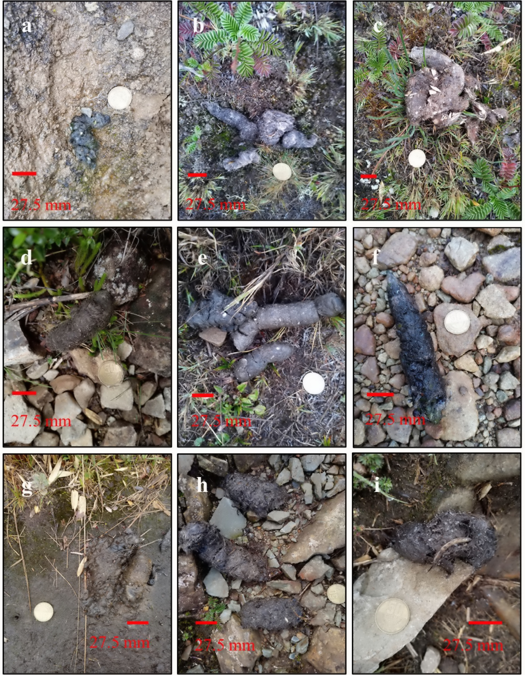
Figure 2. Photographs of scats of the coyote, Canis latrans, measured during the walk through the subalpine layer of the Parque Nacional Chirripó, Costa Rica: a) Base Crestones trail (3,440 m); b-c) Valle de Los Conejos (3,470 m–3,473 m); d-h) Main trail (3,490 m–3,697 m); i) top of Cerro Chirripó (3,821 m). The scale corresponds to the diameter of a 50-colon coin (27.5 mm).
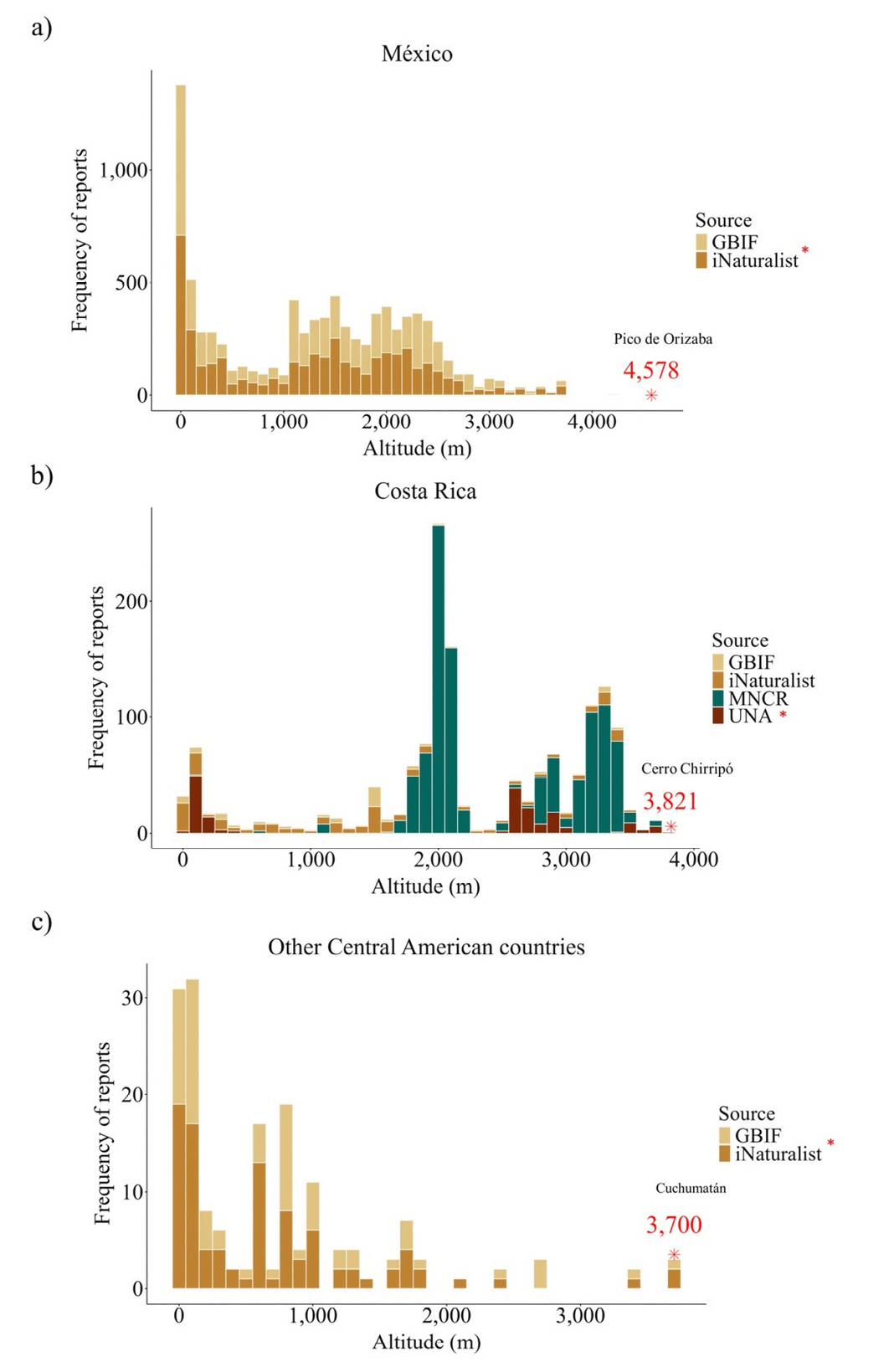
Figure 3. Graphs of frequency of Canis latrans reports from the GBIF and iNaturalist platforms and the projects “Ethnoecology of C. latrans” of the Universidad Nacional (UNA) and “Moorlands” of the Museo Nacional de Costa Rica (MNCR): a) for México; b) for Costa Rica; c) for other Central American countries.